|
|
Post by rockman on Sept 20, 2006 19:45:06 GMT -5
Wondering if anyone knows what the elevation change is at Kennessaw.
What is the climb from burnt hickory to the top of the mountain if you go up the trail?
What about the up and down on a few of the different loops?
Any information would be greatly appreciated as I'm starting to think about heading out to Seattle next July for the White River 50 and the elevation change out there seems a little daunting.
|
|
mattk
Stunned Runner
 Suck it up
Posts: 58
|
Post by mattk on Sept 21, 2006 4:29:52 GMT -5
Rockman Dunno about Kennesaw, but you can get good aggregate vertical feet on the AT in N.E. Georgia. I trained for pikes peak marathon on and around Tray Mountain, just north of Helen. From the trailhead to the summit is about 5.7 miles, and the round trip 11.4 gives you about 3200'. You can also go up and over Tray on the out and back, and pick up additional vertical. Running from the base of the switchbacks to the trail head and then to the summit makes for a good long run on hilly terrain, and the pass road through the switch backs gives you a steady uphill grind the warm up, and a good taste of downhill running with tired legs on the way back.
|
|
|
|
Post by janice on Sept 21, 2006 7:56:18 GMT -5
I've measured the change from Burnt Hickory to the top via the trail using my watch altimeter, and i think it was around 900 feet. I will check next time i run up the mtn.
i agree that N.GA will provide you the best training for the hills you will experience at White River. I ran it awhile ago and it had quite a few long climbs, but i don't remember thinking there were too bad, just long (required walking). It's a great event, i highly recommend it. If the weather is clear, it is also has amazing views of Ranier.
janice
|
|
|
|
Post by rockman on Sept 21, 2006 21:45:04 GMT -5
Thanks for all of the information. Sounds like I need to check out the AT in the coming months. I'm assuming its a ghost town up there in the winter.
Janice, if you get a reading on the elevation change this weekend, let me know.
Greatly appreciated.
See ya on the trail.
|
|
|
|
Post by NGeorgiaTR on Oct 2, 2006 15:32:37 GMT -5
I pulled these from a couple of runs last spring. -Paul Here's the profile for a couple of laps up over Kennesaw and Little Kennesaw and back around, starting from the parking lot. 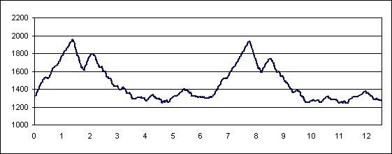 For N. Georgia, here's one from 1 lap of the Coosa Backcountry trail out of Vogel state park, going counter-clockwise. 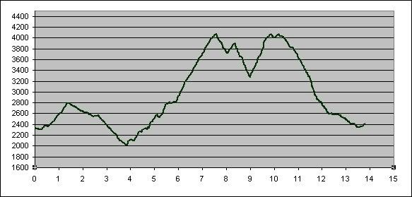 |
|
|
|
Post by rockman on Oct 4, 2006 20:03:57 GMT -5
Paul,
This is great information. Thanks for providing. Greatly appreciated.
Based on this information I'm feeling pretty good about this weekends StumpJump.
|
|


